
MIRADA ROAD
Coastal Trail Bridge replacement — scroll down.
Surfers' Beach & Miramar Shoreline Erosion & Armoring (slide presentation Feb 2021)
Mirada Rd SLR Asset Vulnerability Profile 2018

Along Mirada Road in Miramar, inevitable deterioration of rock slope protection (riprap) from wave action is ongoing.
In March 2024 Mirada Rd was reduced to one-way northbound traffic due to winter storm wave damage (DPW project webpage). Mirada Rd is part of the CA Coastal Trail and a critical link for residents, commuters, and visitors to the area, as it provides the only bike/ped access seaward of Highway 1 in this segment. Short-term emergency repairs will commence early fall and last about two months (Project fact sheet — Emergency CDP — plans).
Connecting Alameda Ave between Medio & Magellan would provide for safe bike/ped access when high surf conditions make Mirada Rd unsafe. This alternate connection would also restore and improve vehicle circulation now that Mirada Rd is one-way only, and will likely remain that way even after repairs are made, in order to give higher priority to Coastal Trail users.
12/28/2023 Bike/ped wave hazards on Mirada Rd. During coastal storms and high surf, people are warned to stay away from the shoreline for their own safety. Mirada Rd is clearly the shoreline, yet there is no alternate route except SR-1.
Mirada Rd Timeline
1905 Shore Acres subdivision created 60’W Mirada Rd (then called Balboa Blvd) — parcel map
1959 City of HMB incorporation included “cherry stem” west of Mirada Rd center line to Coronado/SR1, then north to what is now Sam’s Chowder House.
<1977 Initial armoring installed before Coastal Act when no CDP was required.
2009 emergency armoring repairs between Magellan & pedestrian bridge
2016 Feb/Oct: Coastal Commission granted two emergency permits, G-2-16-0018 to HMB for supplemental riprap boulders at toe of bank approximately 100 feet south of Medio Ave, and G-2-16-0066 to SMC for roadway shoulder revetment repairs between Magellan and Medio. Armoring under CCC emergency permit is considered temporary and subject to removal until a regular CDP is approved.
2016 June: County considered a retaining wall system and one-way traffic for Mirada Rd erosion protection, but did not pursue the project.
2016 July: County Sea Level Rise Adaptation Design Charrette with breakout discussion on Mirada Rd (sketch of graceful retreat concept), and follow-up MCC meeting (video of Item 4b & minutes) where Supervisor Horsley spoke about the need to meet with property owners about forming a benefit assessment district going forward, that the long-term solution is retreat, and managed retreat won’t be paid for by the County (meaning other county taxpayers).
2018 SMC Sea Level Rise Vulnerability Assessment Final Report includes these Mirada Rd Inundation/Erosion Hazard Maps and SLR Asset Vulnerability Profile.
2020: Public Works Director Jim Porter said at Aug 12 MCC meeting that the County stepped back from working on Mirada Rd and will be looking to the newly formed countywide Flood & Sea Level Rise Resiliency District (One Shoreline) for solutions, to protect or retreat.
2021-2023: OneShoreline initiated a study to define a comprehensive shoreline management approach from Pillar Point to Medio Creek focused on addressing the impacts of erosion and sea level rise in the long term. The concepts from this study were presented to the Harbor District in May 2023 but were not well received by the Harbor Commission & District Manager, and OneShoreline has dropped the project.
2024 Feb: One Shoreline made a presentation to the Board of Supervisors. There were no projects in the unincorporated Midcoast.
2024 March: Mirada Rd southbound lane closed due to winter storm wave damage, making Mirada Rd one-way-only northbound with entry via Medio and exit via Magellan. DPW project webpage
2024 Oct-Dec: Short-term emergency repairs between Magellan and Cortez (Project fact sheet — Emergency CDP — plans).
Coastal Commission Shoreline Armoring Decisions
No seawall to protect Coastal Trail south of Mirada Rd (pending litigation)
July 2019 CCC decision denied a section of seawall proposed to protect the Coastal Trail west of Casa Mira condominiums on Mirada Rd (revised findings). The Commission approved the seawall only where needed to protect the pre-Coastal-Act 3-story apartment building at 2 Mirada (built in 1972), but not for the Casa Mira condominiums (built mid 1980’s), nor for the Coastal Trail which can be rerouted east of the condos to Mirada Rd. Casa Mira sued the CCC.
Ongoing Litigation: The California Coastal Act limits the use of shoreline armoring to serve coastal-dependent uses or to protect existing structures. At issue in Casa Mira litigation is whether “existing” is defined as when the Coastal Act was enacted in 1977, or later, at the time of permit application for coastal armoring. The final decision will have significant consequences for the future of the California coast. (5/19/23 Grist article)
Casa Mira vs CCC (19-CIV-04677) petitioned to overturn the 2019 CCC decision that effectively denied the seawall. Trial court issued 1/10/23 tentative decision to grant the petition. CCC authorized an appeal (9/1/23 JD Supra article). On 9/11/24 the Surfrider Foundation filed an amicus curiae (“friend of the court”) brief in support of the CCC’s regulatory authority, and legal mandate, to protect beaches from new coastal armoring. The First District Court of Appeals issued a final opinion 12/12/2024 overturning much of the lower court ruling, agreeing with CCC Jan 1, 1977, cutoff date for “existing development" to be allowed coastal armoring. The appeals court said the Casa Mira homeowners still can get the sea wall however, but only because it would protect a portion of the CA Coastal Trail that runs between the condos and the beach, making it a “coastal dependent” use. At its February meeting, the Coastal Commission will decide whether to seek a review of the decision by the California Supreme Court.
Casa Mira vs CCC & City of Half Moon Bay (21-CIV-03202), 6/9/21, challenges CCC approval of HMB’s 2020 amendment to its Local Coastal Program

Just south of Arroyo de en Medio, the existing unpermitted section of riprap around the parking lot of the 3-story apartment building is the subject of a separate CCC enforcement action.
No armoring of creek banks
Aug 2020 CCC decision on appeal of Moss Beach bluff-top house (staff report) included prohibition of future armoring of the adjacent steep banks of Dean Creek ravine which fall under the LCP definition of coastal bluff (just as do the banks at the mouth of Arroyo de en Medio). Deep piers & tie-back foundation for coastal hazard stability was also prohibited because it is a form of coastal armoring. These foundations have been used in Miramar in the past, and they would interfere with managed retreat from sea level rise and erosion.
Mirada Rd Coastal Trail Bridge Replacement
Construction of the Mirada Road Pedestrian Bridge replacement occurred 2022-2023. In addition to the aluminum bridge, the project includes shotcrete retaining walls with protective riprap at base, and a stairway to the creek bed east of the bridge for beach access, with a total cost of more than $4.7 million. DPW project page.

New Mirada Rd Bridge opened to the public October 26, 2023.
The original concrete arch bridge over Arroyo de en Medio Creek was built in 1917, and was closed to vehicles after completion of Hwy 1 in the late 1950’s. A steel pedestrian bridge was installed over the top of the failing concrete bridge in 2003, which served as the Coastal Trail until abruptly closed as unsafe in July 2020, requiring detour to Hwy 1, the only other north/south route over Arroyo de en Medio for all users.
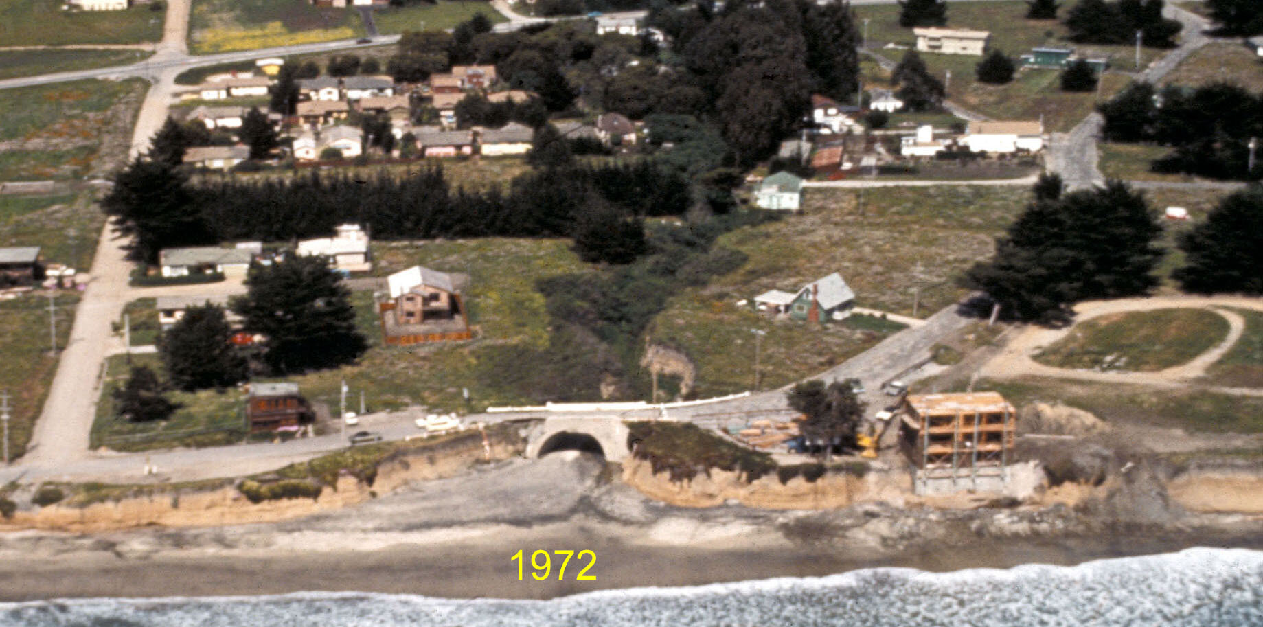
CA Coastal Records Project 1972
Bridge Replacement Timeline/Documents
2001-10-09: MCC P&Z Committee comment on permit application to construct steel pedestrian bridge over the top of the failing concrete Mirada Road Bridge: Agree it would have no impact on creek corridor or beach area and would like to ensure that no riprap is added. Encourage Granada Sanitary District to re-route the sewer line off the bridge, and County to eventually remove the arch structure to allow the creek bed to be full-sized and unobstructed.
2017-04-03: Permit application #2-17-0289 to Coastal Commission (CCC) to construct soil nail reinforced, sculpted shotcrete walls to address the eroding shoreline at the pedestrian bridge over Arroyo de en Medio. See 4/13/18 Sand Supply Study for project details. Filing status incomplete and application withdrawn 6/3/20.
2018 summer: Structural engineering evaluation of bridge estimated two more years of life (oral report by DPW at MCC 8/12/20 meeting after bridge closure).
2018-11-13 Board of Supervisors approves $336K for design consultant for 3-year bridge replacement project but the public is unaware due to inadequate #30 consent agenda item wording which does not mention the bridge. Preliminary construction estimate $3.5M.
2019-01-23: DPW request for support of bridge replacement grant application —
MCC email reply in support with MCC request for involvement in development of project specifics.
Grant application not funded.
2020-06-03: Permit application to Coastal Commission — DPW asks to withdraw 2017 Permit app #2-17-0289 (soil-nail walls north & south of bridge) and submit new CDP application to include replacement of the pedestrian bridge, and hybrid armoring consisting of shotcrete walls with tieback anchors as well as rock slope protection along the banks of Arroyo de en Medio.
The following previously unreleased documents were obtained from CCC staff in Oct 2020:
Application cover letter & additional info 6/3/20
Sand supply study 4/13/18
Geotechnical Investigation 1/10/20
65% Design Plans 1/16/20
Permit application follow-up info & studies
CCC info request 7/15/20 -- DPW reply 8/10/20
CCC info request 9/17/20 -- DPW reply 12/15/20
Lengthen bridge option 2/21/21
DPW to CCC final memo 4/16/21
2020-07-27: Bridge closed as unsafe (press release).
2020-08-12: MCC agenda item on Mirada Rd bridge & detour (bridge condition, detour, minutes, video @17min). None of the bridge replacement documents & correspondence were available to the public until posted here 10/6/20.
2020-09-21: Detour safety improvements on Hwy 1 completed
2020-10-14 & 10-28: MCC letter, slide presentation, correspondence received.
2020-12-09: MCC agenda on bridge — County memo, DPW presentation
2020-12-16: NOA and IS/MND (project CEQA review) — MCC 1/13/21 comments
2021-02-09 Board of Supervisors certifies the project CEQA document, agenda item #24.
2021-02-10: MCC letter in support of bridge replacement with qualifications
2021-05-14: Coastal Commission approved the CDP for Mirada Rd pedestrian bridge replacement at current location fronted by new sculpted shotcrete seawall on both sides of the mouth of Medio Creek. Staff Report - Exhibits.
2022-04-26 Final Construction Plans received dated 2022-01-31.
Summer 2022 to fall 2023: Sea wall construction June to December 2022. Aluminum bridge installation spring 2023, and concrete beach-access staircase summer/fall 2023.
2023-09-26 Construction cost increase to new total of $4.7M (staff report).
Project contacts: Lane Grover, Project Manager, Zack Azari, County Construction Project Manager.
2023-11-29 DPW presentation on end-of-wall erosion