Fitzgerald Marine Reserve (FMR)
& Pillar Point Bluff - map
Tide Pools
What to know before you go tide pooling (30-sec video)

Advanced reservations are required for groups of 10 or more to visit the Marine Reserve. Limiting the number of persons on the reef at any one time, reduces impact on marine life, and helps to preserve it for future generations.
Friends of FMR is a non-profit organization of volunteers who provide tours of the tidepools and other educational experiences.
Natural Resources
Issues:
Reef overuse has led to decreasing biodiversity.
Cliff armoring has caused loss of beach.
Invasive non-native plants degrade native habitat.
Vegetation Management Pilot Projects:
Upland vegetation restoration 2014/15: Cypress Grove & San Vicente Creek
SMC Parks Stewardship Corps: Volunteers & park staff work together to restore native habitat.
Pillar Point Bluff & Marsh - map

1997 Pillar Point Marsh acquired by County
2004-2009 POST: bluff acquisition, restoration, trails: presentation
2011 Bluff parcels transferred to County: press release
2015 POST acquires last (Thompson) parcel: staff report
2016 Geotech Hazard Assessment: report
2016 Thompson parcel transfer to County: staff report
2016 MCC presentation on trail surfaces
2018 Jean Lauer Trail road rehab project: blog post
2019 Air Force trail erosion/restoration project description — plans — Coastal Prairie interpretive signage
2022 Pillar Point Bluff Pilot Off-Leash Dog program CDP denied 5-0 by SMC Planning Commission. MCC comments
Pillar Point Bluff invasive plant management: webpage
Infrastructure Projects
Feb 2013 MCC presentation: Review of FMR Infrastructure projects & natural resource protection issues
Parking Lot Improvements completed 2014
The parking lot project (PLN2012-00126) at the corner of California & Lake Street, Moss Beach, initially involved a major reconfiguration, enlargement, and complete repaving (6/11/12 site plan). After Planning Dept review noted extensive project encroachment on the riparian buffer zone (staff report), the project was significantly scaled-down, focusing mainly on stormwater pollution reduction features.
Dardenelle Trail completed 2013

The California Coastal Trail bike/ADA route through FMR is the Dardenelle Trail, along the park's eastern boundary between Cypress and North Lake Street. The 60' long, 8'4" wide bridge across San Vicente Creek also provides improved inter-community bike & pedestrian access.
Public input on project plans in 2010 resulted in reduced width for trail and bridge, and more natural decomposed granite trail surface instead of asphalt. However the construction footprint was not reduced and the trail was constructed with road paving equipment causing a wide swath of destruction.
See Feb 2013 MCC presentation, slides 7-15.
May 2011 California Coastal Commission staff report - approved.
Jan 2011 Planning Commission Approval/Conditions / Staff Report.
Comments: Committee for Green Foothills / L.Ketcham
2010 Trail plans / NegDec

Seal Cove Staircase built 2010
Interpretive Center
Earlier plans for enlarged Interpretive Center (2,000 to 3,000 s/f) at main entrance will not go foward unless adjacent property becomes available for purchase, according to 2016 Master Plan Assessment.
Moss Beach Reef Access Ramp & Overlook
Managed retreat for the reef overlook platform is proposed in the 2016 Master Plan Assessment, instead of the $2.5 million access ramp expansion with 10.5-ft wide asphalt road, 3-ft wide shoulders, retaining walls up to 6-ft high, and enlarged rock platform on the beach -- 2010 ramp design & NegDec
2010 Comments: L.Ketcham & Green Foothills
Feb 2013 presentation (slides 18-26).
Master Plan
2002 FMR Master Plan
2002 FMR Vegetation Resources
2003 FMR Draft Environmental Impact Report
2004 FMR Marine Resource Assessment
2004 FMR Conceptual Plan for Interpretation
[2013 MCC presentation: request for progress/priority assessement]
2016 Master Plan Assessment
2017 Master Plan Progress Report & presentation
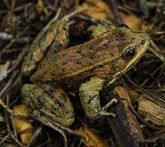
2012 image of California red-legged frog at FMR